Author’s Note:
The following is part memoir and part a summary of events that occurred during the 1965 Arkansas River Flood as documented during and after the flood 50 years ago. I have liberally quoted from references because they were so descriptive and well written.
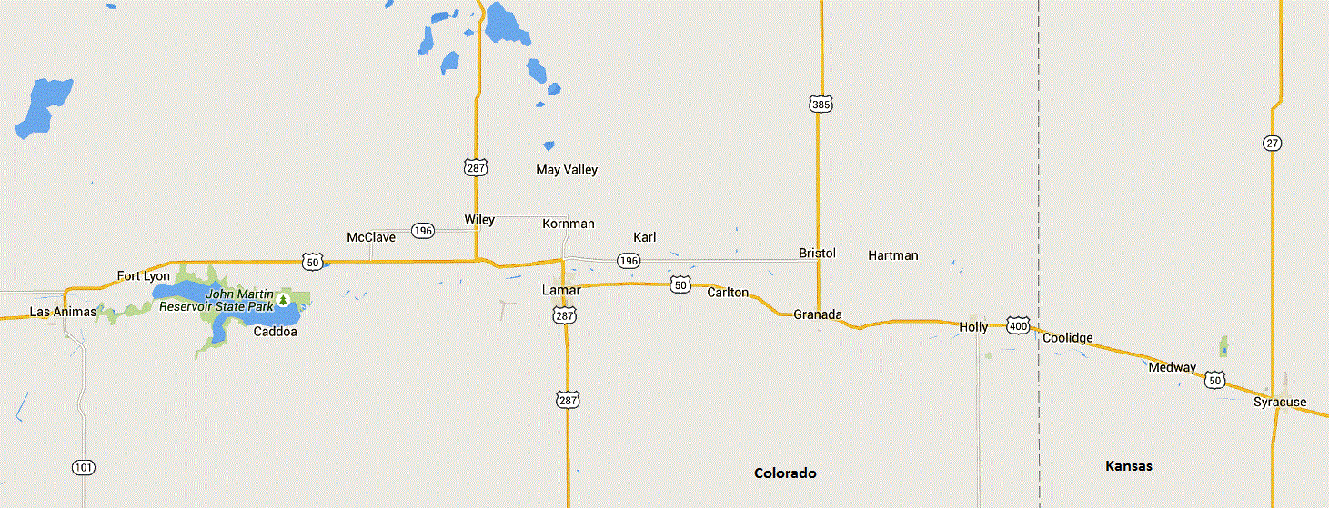 In 1965, I was a kid living at Granada, Colorado. I remember the 1965 flood! It had been humid and raining off and on in southeast Colorado for most of the month of June. Although when the big storm began it was dry in Granada, it was really hot and humid. There had been good rains at several places in the Arkansas River valley (Snipes 1974:D7; USACE 1976:II-26). Looking at data collected during and after the storm, flooding from the “rain storm” began on June 14, and lasted through June 18 (Colorado Legislative Council 1965; Snipes 1974; UCAR 2007; USACE 1966, 1974, 1976, 1983). It was a long five days and then it took several months and in some cases several years for local residents to get back to anything that resembled normal.
It must have been the evening of June 17 that the old levee on the west side of Granada broke.
“The [rain] gauge at Granada recorded 5.38 inches on the 17th with a maximum intensity of one inch in a hour” (USACE 1966:4).
We were running the movie theater that evening; my brother Norman and I helped out with the concession stand and were learning to run the projectors while Dad sold tickets. A friend of ours, Wayne James, was running the projectors that night. Our Dad, Herman P. Everhart, Jr. was helping the town folks with sand bags at the levee on the west side of town, so my mother, Marilyn, came down to the theater to help Norman and I (my younger sisters were probably at home with a baby sitter, and brother Phillip wasn’t born yet). I think the old levee had been built in the 1940s to protect the town from Wolf Creek. Dad told us the situation at the levee didn’t look good.
At about 11:30 p.m., when the movie was over, we closed up and went home to get ready for bed. I think there were two or three family friends that were visiting with Mom, one being the babysitter, when we got in bed. We just barely laid our heads down when Dad came home and told us we had to evacuate. We grabbed a few clothes and jumped in the car and headed for the hill south of town; as they say “head-for-the-hills” (Snipes 1974:D3). By the time we had packed up and got to Main Street to turn south, maybe 7-8 minutes and about four blocks, the flood water was already about a foot deep in the intersection and flowing fast; Dad stopped for a minute at the stop sign and let us get a look. Even though it was raining pretty hard, we could distinctly hear the town’s tornado/fire siren blowing.
Heading up the hill, it seemed odd to see the huge line of cars and pickups parked along both sides to the gravel road on that hill south of town. While most everyone left town, there were a number of folks that stayed in their homes overnight; because it was already late, many of them were in bed asleep, and didn’t hear the siren.
Once Dad got us up on the hill, he got a ride back into town. We also had a hardware business; the Granada Lumber Company and the Granada Theater were in the same building. Our grandfather, Herman P. Everhart, Sr. and Dad had built that brick building from the ground up shortly after World War II. Dad had been a communications man during the war and knew electronics and radio. He liked Granada and wanted to provide the community with some entertainment, therefore, they made the theater. Our Uncle Don ran the hardware store. Dad was quite a man! He was active in the community especially with local emergency preparedness type things including Civil Defense and the Civil Air Patrol. Later, he was Mayor of Granada for several terms.
After he left us on the hill, Dad spent several nights in that hardware/theater building, sleeping on a cot in the attic. In order to reduce damages, he worked long into the night carrying things up into the attic and putting things as high on the shelves as possible trying to save as much as he could from the flood water. The next morning, a number of folks woke up to step into water. I think there were about 500 people living in Granada at the time; all but about seven houses in town were flooded. Our house was one of those; Dad had built our house on a high foundation in the early 1950s before I was born. Several days before the flood, Dad had Norman and me shoveling dirt up against the crawl space doors at the back of the house to prevent flood water from getting under the house. Flood water got half an inch up on our front door sill (approximately 30 inches in depth); about another inch and it would have gotten in the house. There was about 5 feet of water that resulted in about a foot of mud that got into the hardware/theater building and my grandparent’s house, both of which were located on the south side of U.S. Highway 50.
We were fortunate. We spent two days and nights in our car and then got an offer to stay in the basement of Henry Witt’s house about 6 miles further south. I remember that we could hear the water flowing about a quarter of a mile south of their house. At night, the house seemed cold and damp and like most of southeast Colorado had no electricity. There were salamanders in the window well outside of where we slept. We stayed at Witt’s two nights then, luckily, were able to get back into our dry house in town. Most of the Granada folks stayed and slept in their vehicles for a week or more.
Everything in town was a huge mess after the flood! The flooding in Granada was from a backwater area along the old levee and luckily, the town did not get the direct brunt of the Wolf Creek flows! Wolf Creek flows out of the sand hills southwest of town proceeding northeast toward the river until it is channeled to the east, directly toward Granada, along the south side of the AT&SF railroad grade. Immediately west of town the creek meets the old levee and a hard turn to the northeast as it crosses until the railroad trestle. Thankfully, the levee held at this point. Even the flows from the backwater washed out huge sections of the AT&SF railroad tracks in town. The Wolf Creek peak flow was estimated to be 35,300 cubic feet per second (cfs) (USACE 1966:10, 1972:38). Our southeast part of town was also lucky in the fact that the hardest Wolf Creek flows traveled to the northeast through town and bypassed our neighborhood. Our front yard was covered with about a foot of mud along with a dead pig and cow.
At our grandparent’s house, which was immediately east of the hardware/theater building, we scooped 6-8 inches of mud out of the house so that we could then roll the soggy carpet up into a sloppy roll. Dad hooked a log chain to it and pulled it out of the house with a tractor. There was also a similar amount of mud in the hardware/theater building. We had an old early 1950s refrigerator in the back of the building. Dad had unplugged it before the water got too deep. After the electricity came back on, we just washed it off and plugged it back in and it ran for another 30 years.
We had a small farm field and livestock corrals on the west side of town between the old levee on the west, Highway 50 on the south, and the railroad tracks on the north. During the flood we had about 50 head cattle with calves in the corrals that were built on a small sand dune knoll. A few days after the flood, Norman and I helped Dad carry the calves out to our pickup, wading shoulder deep in standing water (almost 5 feet deep). Once we had the calves in the pickup, we opened the gate and the cattle swam out, following us through the back streets of Granada to the south where we turned them loose in the sand hills. With help from others, Dad gathered the cattle back up about a month later. About a week before the storm, our hardware store received a semi-load of galvanized metal stock water tanks. Everyone had been busy and no one had had time to take the plugs out of the tanks. When the flood came, a lot of those stock tanks washed away - with the plug in them, they floated. Weeks later we found some of the stock tanks as far downstream as Lakin, Kansas. We never found more than half of them.
At that time, Dad had an airplane. I don’t know what day, but Dad got a ride to the Lamar, Colorado, airport on one of the Army or National Guard helicopters; he brought his plane down to Granada and parked it on the edge of the gravel road on the south side of town just in case it might be needed. About a day later, someone had a heart attack and Dad flew them to Lamar so they could get to the hospital.
In a few days after the flood water subsided in Granada, Doc Ward from Holly, Colorado, came over to Granada and started giving everyone cholera and tetanus shots. I think the highway to Holly was still closed so I think the Army or National Guard had flown Doc in with the serum and generators to provide for refrigeration. We were lucky we got our shots from Doc. Although he was in a hurry, he used the hand-held syringes and was easy with us. In another day or so, the Army/National Guard medics were in town and they used the compressed air syringes to give the shots which were really hard on a lot of people. The town of Granada was hard hit but Holly was nearly devastated by flood water; at Holly there was about 8-11 feet of water in downtown. A few days after we got our shots and the highway was reopened to Holly, Mom, Norman and I drove to Holly and helped clean Doc Ward’s office. Most of the mud had already been shoveled out. We washed down the walls and mopped the floors with Clorox.
We kept hearing rumors that John Martin Dam had broken; of course it hadn’t but the rumors kept everyone on edge. Fortunately for southeastern Colorado, John Martin Dam held all of the front-range flood water that was coming down the Arkansas which included the large tributaries of Fountain Creek, the Purgatoire River, and Rule Creek.
Years later, in the late 1970s and again in the late 1980s and early 1990s when I worked summers at John Martin, Mr. Albert “Al” Fuller, the John Martin electrician who had worked there since the early 1950s, told me that the dam was empty before the heavy storm started. In four days they had 164,000 acre-feet of flood water stored; by June 25 there was 313,300 acre-feet store (USACE 1966:9, 1976:II-26; Snipes 1974:D-60). This was the largest storage ever recorded at John Martin (reaching an elevation of 3,856.16 feet) and Al said that even the Corps employees were nervous about the situation. The previous highest storage had been ten years earlier when the dam had held back 260,000 acre-feet (USACE 1983:4-8). In 1965, the Corps did not resume making any releases from the dam until July 6, after the serious flooding downstream had eased (USACE 1966:9).
As a side-bar to how thunderstorm rainfall flows: One afternoon with a big thunderstorm in the southwest near Trinidad, Al said “Watch, in two or three days, water from that storm will come down Rule Creek and make a puddle in front (upstream) of the dam.” Sure enough that’s what happened. In a similar kind of way, as the June 1965 rains shifted and moved across the landscape, dumping in some places, moving with little rainfall and then intensifying in other places, different creeks flowed with peak flooding in different areas at different times.
For those that aren't familiar with the dam and reservoir, the concrete crest at John Martin Dam is at an elevation of 3,840 feet and the huge tainter gates, at one time the largest in the world, are 35-feet tall. In terms of storage, the top of the conservation (irrigation) pool is at an elevation of 3,851.83 feet; therefore, the June 25 record storage was 4.33 feet into the flood-control pool storage space and 11.83 feet up on the face of the tainter gates. The landscape at John Martin Reservoir is relatively shallow and flat, and 4.33 feet in elevation can result in surface water that is an additional 1/2 to 3/4 mile in width and several miles in length.
Data for the storage of flood water at John Martin Dam helps explain the story of the damages prevented by the dam: On June 14 at 8:00 a.m. there was -0- storage. At noon on June 15, there was 3,350 acre-feet and at 6:00 p.m. on June 16, 5,990 acre-feet. “The gates in John Martin Dam were closed at 7:30 a.m. on 17 June 1965...” (USACE 1966:17; Snipes 1974:D18). At 6:00 p.m. on June 17, there was 10,160 acre-feet stored. On June 18, at 3:00 a.m. there was 19,200 acre-feet; at noon, 79,120 acre-feet; and at midnight, 179,400 acre-feet. On June 19 there was 194,900 acre-feet of flood water recorded at 6:00 a.m. and 223,000 acre-feet at midnight. After that, the pace of inflowing water began to slow until storage peaked about midnight on June 25 at 313,300 acre-feet (Snipes 1974:D60).
The June 14-18, 1965, storm was caused by “... a strong and persistent weather pattern which had existed over the western United States for about four months” (USACE 1966:1). There were a number of factors that produced the storm: “... unseasonably cool air at 20,000 feet,” “increasing surface pressures over the central plains, coupled with a low-pressure area centered over Chihuahua, Mexico, [that] induced an inflow of moist Gulf air into northeastern New Mexico and eastern Colorado, damming it up against the Rocky Mountains beneath the cold air aloft. This combination of surface and upper air conditions resulted in extremely unstable atmospheric conditions and reinforced with mechanical [orographic] lifting (due to the upslope of the terrain) and convergence (due to the low-pressure pattern), produced phenomenal rains and calamitous floods” (USACE 1966:1-2, 1972:37-38; Snipes 1974:D7).
Essentially, all of eastern Colorado and northeast New Mexico east of the Rocky Mountains and some portions of western Kansas received heavy rains from this storm. Across the region, there had been near “continuous rain through the month of June 1965...” (USACE 1976:II-26). Southeastern Colorado was one of the heaviest hit areas during the massive, stalled, low pressure storm event (USACE 1966:1-13; Snipes 1974:D4, D7). Flooding began on June 14. Generally, “in southeastern Colorado, there was an 18-inch total storm center over southern Prowers County, and an 16-inch center over eastern Prowers County” (USACE 1966:3). There is documentation of single day and storm event rain records such as the 14 hours before 1400 hours on June 16 when 15.5 inches was observed 28 miles south-southeast of Lamar” and “Holly reported a 24-hour total of 11.08 inches at 6 a.m. on the 17th [of June]” (USACE 1966:4; Snipes 1974:D7). It was raining almost everywhere in southeastern Colorado. Although not official, we heard reports from ranchers living out on the prairie 20 to 50 miles south of the river that said they had empty stock tanks before the storm that had filled and overflowed. A standard galvanized stock water tank measures 22-inches in depth.
One example of a peak discharge is that on Rule Creek which flows directly into John Martin Reservoir from the south at the railroad “trestle.” Measured at the Muddy Creek confluence with Rule Creek south of Las Animas, the peak discharge measurement of 278,000 cfs was the result of the failure of the private Setchfield Dam. The flow was attenuated as it moved down the Purgatoire and the flood peak at the Purgatoire's month was 62,500 cfs (USACE 1983:4-8).
All of the flooding that we experienced in the Lamar/Granada/Holly area was from the Arkansas River tributaries downstream of John Martin Dam. Examples from the peak discharge data from right-bank (south) tributaries include: on June 17, Wolf Creek near Granada, 35,300 cfs and Two Butte Creek at Holly, 182,000 cfs; and on June 18, Caddoa Creek immediately downstream of John Martin Dam, 37,600 cfs; Mud Creek, 53,400 cfs; Dry Creek, 28,300 cfs; Willow Creek, which flows through the east side of Lamar, 24,300 cfs; and Clay Creek, a few miles east of Lamar, 158,000 cfs which destroyed the newly constructed Clay Creek Dam (USACE 1972:38). On the Arkansas River, continuing on downstream into Kansas, on June 17, Coolidge, 158,000 cfs and Syracuse, 174,000 cfs; and on June 19, Garden City, 130,000 cfs and Dodge City 82,000 cfs.
As noted, these tributary flows were records. Caddoa Creek flows from the south under the AT&SF railroad trestle which even though it is open, sort of restricts the flow. Old timers like Don Doyle who lived in Caddoa at the time, said that flood water backed up about two miles behind the trestle for several days because there was so much water flowing down the creek it couldn’t flow under the trestle fast enough. At Mud Creek, the width of the railroad trestle is even narrower. Water also backed up behind this trestle and the force of the flow created, it was said, a plunge pool that was about 100 feet deep; the water excavating the sandstone bedrock and spreading numerous small and several car-sized boulders across the alluvial fan of several acres.
The flood flows on the Arkansas River progressed down the river in surges as each of the tributaries reached their peaks. At Lamar, on June 18, the Arkansas River recorded 73,800 cfs. Lamar’s downtown and the area north of the railroad tracks had about 4 feet of water from the flood water surge that was moving down the valley (USACE 1966:9). Willow Creek “…spread havoc in the southern and eastern parts of town” (Snipes 1974:D18). Construction of the Clay Creek dam, located southeast of Lamar was almost complete when the rain started.
“Rains on the upper watershed on the night of 16 June filled the newly constructed reservoir to its capacity of about 3,000 acre-feet, and it spilled. Observers stated that during the night of the 16th water overflowed the confines of the reservoir area and backed into a sand dune area to the northwest of the dam. The following night (17 June) floodwaters producted a peak discharge above the reservoir of 158,000 c.f.s. The volume of this runoff exceeded the design capacity of the project and the dam was overtopped by about three feet. This resulted in a beach about 300 feet wide at the left end of the dam and water was backed into the sandhills to such an extent that another breach occurred in the sandy terrain about 1,000 feet wide and 30 to 40 feet deep. Severe damages to U.S. Highway 50, AT&SF Railway, and farmlands were sustained” (USACE 1966:9-10).
Many folks will remember that these flood flows also destroyed the Lamar drive-in theater.
At Holly, the Arkansas River one peak flood crest that was estimated at 160,000 cfs (Colorado Legislative Council 1965:5) and flows from Two Butte Creek which enters the Arkansas from the south were huge. “Two Butte Creek entered the Arkansas River valley as a raging torrent with a peak discharge of 182,000 c.f.s. at about 2 a.m. on 17 June” (USACE 1966:10). It was said that the Two Butte Creek flows flowed over the top of the Arkansas River flows. The AT&SF in a way saved Holly from being entirely washed away. The railroad tracks are located on the south side of town and there were about eleven railroad box cars that were parked there; these cars steadied the flood.
Although it’s been 50 years ago, everyone that was in the valley still has lots of memories. “The total damages in the Arkansas Basin above Great Bend [were] estimated at $57,283,000...” (USACE 1966:24). “The estimated damages prevented by [the storage held by] John Martin Reservoir [were] $48,206,000…” (USACE 1966:30).
References
Colorado Legislative Council
1965 Report to the Colorado General Assembly: 1965 Flood Disasters in Colorado. Research publication No. 106. http://www.law.du.edu/images/uploads/library/CLC/106.pdf. Accessed June 23, 2015.
Snipes, R. J.
1974 Floods of June 1965 in Arkansas River Basin, Colorado, Kansas, and New Mexico. Geological Survey Water-Supply Paper 1850-D. U.S. Department of the Interior, Geological Survey. U.S. Government Printing Office, Washington, D.C.
University Corporation for Atmospheric Research (UCAR)
2007 South Platte & Arkansas Basins: June 14-20, 1965. http://www.assessment.ucar.edu/flood/flood_summaries/06_14_1965.html. Accessed June 23, 2015.
U.S. Army Corps of Engineers, Albuquerque District (USACE)
1966 Flood Report, Arkansas River Basin, Flood of June 1965, Colorado, Kansas & New Mexico. Albuquerque District, Albuquerque.
1972 Draft - Report on Review Survey for Flood Control and Allied Purposes: Arkansas River and Tributaries, John Martin Dam, Colorado to Great Bend, Kansas. Volume 2, Appendix D, Hydrology.
1974 Revised Draft Environmental Statement: Review Survey for Flood Control and Allied Purposes, Arkansas River and Tributaries, Great Bend, Kansas, to John Martin Dam, Colorado; Lamar Local Protection Project, Lamar, Colorado. Albuquerque District, Albuquerque.
1976 Final Environmental Statement for Operations and Maintenance: John Martin Dam and Reservoir, Arkansas River, Colorado. Albuquerque District, Albuquerque.
1983 Water Control Manual: John Martin Reservoir, Arkansas River, Appendix A to Arkansas River Basin Master Water Control Manual. Albuquerque District, Albuquerque.