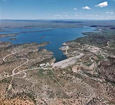
Santa Rosa Dam and Lake was authorized by the Flood Control Act of 1954. The Project consists of an earthfill dam about 7 miles north of Santa Rosa, New Mexico. The main embankment was completed in the spring of 1981. Dam construction and development of the area was a $43 million federal project.
Santa Rosa Dam is the first major dam along the Pecos River, with a 2,434 square mile contributing drainage area. It is a main component in the Pecos River Basin comprehensive plan, providing irrigation storage, flood control and sediment retention.
Santa Rosa Lake is a U.S. Army Corps of Engineers-managed dam. There are a few Corps-managed day use areas with no fee. The campgrounds and most recreation areas are managed by New Mexico State Parks.
America the Beautiful Discount Passes are not recognized as this is a N.M. State Parks-managed recreation area.
N.M. Game & Fish weekly fishing reports
N.M. fishing regulations
N.M. fishing license information
Geocaching is permitted at Santa Rosa Lake only with the approval of the project manager.
Area Weather: Current weather conditions for Santa Rosa Lake.
 Protect Your Waters and Stop Aquatic Hitchhikers!
Clean, Drain & Dry before transporting your boat or equipment.
For more information, click here.