Geographic Setting
 The URGWOM modeled area includes the Rio Grande from the headwaters in Colorado to Hudspeth County, Texas, the Conejos River, the Rio Chama including the San Juan Chama Project diversions, and the Jemez River. URGWOM simulates reservoir storage and operations at Heron, El Vado, and Abiquiu Reservoirs on the Rio Chama, Jemez Canyon Reservoir on the Jemez River, Cochiti, Elephant Butte, and Caballo Reservoirs on the Rio Grande, Platoro Reservoir in the headwaters of the Conejos River and Nambe Reservoir on the Rio Nambe (water accounting only).
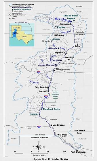
The Continental Divide is the western boundary of the Rio Grande Basin, and the Sangre de Cristo Range and a series of mountain ranges bisecting the state of New Mexico form the eastern boundary of the Basin in New Mexico. Mountain peak elevations within and along the edge of the Basin range from about 8,000 to over 14,000 feet. High plains elevations range from 6,000 to 8,000 feet with elevations in the valley ranging from less than 4,000 to about 6,000 feet.
Above Fort Quitman in Texas, the Rio Grande is about 700 miles long with a drainage area of approximately 30,000 square miles. Tributaries to the Rio Grande in Colorado and New Mexico that have contributing drainage areas greater than 500 square miles are the Conejos River (767 mi2), Galisteo Creek (670 mi2), Jemez River (1,038 mi2 ), Rio Puerco (6,440 mi2), and Rio Salado (1,394 mi2) with the Rio Chama having a drainage area of 3,090 mi2.
The Basin has a semiarid climate typical of the southwestern United States, and highly variable streamflow contribute to the complexity of water management in the Basin. Average annual precipitation over two thirds of the Basin is between 7 inches and 15 inches and exceeds 25 inches only in the high mountain areas where 30 to 75 percent of the annual precipitation falls as snow. Snowfall accounts for less than 25 percent of the annual precipitation in the Basin.
The Basin lies in a transitional zone between the Gulf and Pacific rainfall provinces. The Basin’s complex meteorological conditions are further complicated by the presence of the surrounding mountains. Storms vary in type and magnitude with the seasons. Intense isolated thunderstorms are frequent in the summer months while heavy snow may accumulate in the mountains of northern New Mexico and southern Colorado in the winter. The greatest flood-producing storms have occurred in the transitional seasons, March through May and September through October, when greater temperature differences between air masses moving simultaneously into the region cause increased instability.
Water Supply
Surface water available in the Basin comes from the natural runoff to the Rio Grande and from supplemental sources provided by the San Juan-Chama and San Luis Valley Projects. Miscellaneous smaller sources include a few transmountain ditches in Colorado and discharges of municipal wastewater. The majority of the surface water comes from melting snow. Spring runoff usually begins in March and may continue through June and into July. During the summer months, precipitation from thunderstorms may be a significant contributor to stream flow. Many of the Rio Grande’s largest tributaries are ephemeral and flow only occurs in response to these events. Annual flow volumes in the Rio Grande below the confluence with the Rio Chama as measured at the USGS gage Rio Grande at Otowi Bridge, NM (ID#08313000) from 1896 through 2024 averaged 1,050,000 acre-ft/year and ranged from 358,000 acre-ft/year to 2,590,000 acre-ft/year. In general the Rio Grande is a gaining stream above Otowi and a losing stream below that location.
San Juan-Chama Project
In 1962, Congress authorized construction of the San Juan-Chama Project which is a transbasin diversion system that imports water from tributaries of the San Juan River in Colorado and provides a portion of New Mexico’s allotment under the Upper Colorado River Basin Compact. Water is delivered through the Azotea Tunnel that runs under the continental divide to Willow Creek (tributary of the Rio Chama) then to the Rio Grande via Heron Reservoir and the Rio Chama. San Juan-Chama Project water is used to supplement the native flow of the Rio Grande for the principal purposes of furnishing water for agricultural, domestic, and municipal and industrial (M&I) uses and for providing recreation and fish and wildlife benefits.
During the 1972-2023 period, the San Juan-Chama Project has imported an average of 91,900 acre-feet of water into the Rio Grande Basin annually. Water users such as the Albuquerque Bernalillo County Water Utility Authority (ABCWUA), Middle Rio Grande Conservancy District (MRGCD), and other municipalities and irrigation districts contract with Reclamation for San Juan-Chama Project water. The release, transport, storage, and use of San Juan-Chama Project water is carefully accounted for to assure there is no impact to existing uses of native Rio Grande water in the system. This required accounting is a key need fulfilled with URGWOM and a complex component of the model.
Water Uses, Demands, and Trends
Crop irrigation is the largest surface water use in the Basin, accounting for up to 90 percent of surface water withdrawals. Consumption of surface water for M&I uses is a smaller but increasing demand. Most cities and towns have historically relied on groundwater for M&I supplies, but as urban populations have increased and aquifers are being depleted, surface water is becoming an increasingly important source of M&I water. Both the ABCWUA and the City and County of Santa Fe have commenced with surface water diversions of their allocated San Juan-Chama Project water, and these new specific demands serve as an example of changes in the Basin that complicate water operations and create the need for an accounting tool for the effect of such changes to the system.
Biological resources associated with the Rio Grande are diverse. They are associated with six life zones, or biomes: Arctic-Alpine, Hudsonian, Canadian, Transition, Upper Chihuahuan, and Lower Chihuahuan. The Rio Grande is also an important flyway and provides habitat for numerous migratory bird species. Several federal and state wildlife refuges along the river and valley are specifically dedicated to wildlife management purposes.
Water in the rivers and reservoirs provides habitat for a variety of native and exotic fish species, including game fish. Riparian zones and wetlands provide invaluable habitat for terrestrial and amphibious species. These areas are directly dependent on streamflow for their existence and regeneration. The Rio Grande and the associated riparian zones commonly referred to as "Bosque" provide habitat for listed threatened and endangered species including the Rio Grande silvery minnow (Hyboganthus amarus ) and the southwestern willow flycatcher (Empidonax trailii extimus). Many of the recent needs in regard to the specific capabilities and applications of URGWOM are related to ESA issues.
Hydroelectric power plants are installed at Elephant Butte, Abiquiu, and El Vado dams. Power generation at Elephant Butte may influence water operations at Caballo Dam. The power plants at Abiquiu and El Vado are "run-of-the river" facilities that generate power only when water is released to serve other purposes. Rivers, reservoirs, and riparian areas provide a variety of recreation opportunities, and with an increasing population, there is a corresponding increase in demand for recreational opportunities within the Basin that has an impact on water resources.
Other depletions of surface water are due to open water evaporation and to transpiration by non-crop vegetation. Gross reservoir evaporation ranges up to 80 inches per year and can make up a large component of the overall hydrologic budget especially when reservoirs are full. Surface water is also lost into groundwater systems by seepage from rivers, reservoirs, canals, and ditches.
Infrastructure and Institutional Framework
Waters of the Rio Grande and the various supplemental sources are allocated among users by a complex system of international treaties, interstate Compacts, court decrees, state and federal laws, various contracts, water rights, and established operating criteria. The Rio Grande and most of its major tributaries are controlled by dam and reservoir systems, diversion structures, and artificial channels. Nine main reservoirs and many small reservoirs regulate floods and store water for irrigation, M&I, recreation, and fish and wildlife uses. Diversion structures and conveyance facilities deliver water to users throughout the Basin. The water management infrastructure and its institutional framework are closely related and have developed over time and can perhaps best be described and understood in terms of the history of development:
History of System Development
Irrigation in the Basin by Native Americans predated European settlement but the technology, labor, and capital resources available at that time were insufficient to substantially control and alter the river flow. Acequias and community ditches, many of which are still in use, were adequate to serve local needs. Development had not come to a point where a basin-wide system of water management was necessary.
By the 1880’s, however, increased diversions in the San Luis Valley of Colorado resulted in water shortages downstream, particularly in the Mesilla Valley and in the El Paso/Juarez area. In 1896, responding to pleas from downstream irrigators, the United States government ordered an embargo on additional irrigation development on or crossing federal lands, pending negotiation of a treaty with the Republic of Mexico. A convention was signed in 1906 under which Mexico is annually allocated 60,000 acre-feet of water from the Rio Grande. Elephant Butte Dam, an early Reclamation project, was completed in 1916 to provide a dependable water supply to meet this obligation and for irrigation in the Mesilla Valley and El Paso areas. In 1939, Caballo Dam was completed downstream from Elephant Butte to supplement storage, provide flood control, and regulate hydroelectric power generation at Elephant Butte Dam during years of normal water supply.
By the early years of the 20th century the effects of poor drainage, flooding, and sedimentation in the Middle Valley between Cochiti Dam and Elephant Butte Reservoir had resulted in decreased irrigated acreage and declining agricultural production. The Middle Rio Grande Conservancy District (MRGCD) formed in the mid-1920s to address these problems and help stabilize the local economy. In addition to drainage, flood control, and improved irrigation works, MRGCD built El Vado Dam (completed in 1935) on the Rio Chama to store water for irrigation in the Middle Valley.
In 1938, after years of negotiation, the states of Colorado, New Mexico, and Texas agreed to the Rio Grande Compact (Compact). The Compact is one of the legal cornerstones governing operation of the Rio Grande and its reservoirs above Caballo Dam. It apportions the river water among the three states according to a specified annual delivery schedule that depends on the flow at designated index stations. The Compact is administered by a commission that has a delegate from each state and a non-voting Federal representative.
In the 1930s and 40s, it became apparent that MRGCD and other local and state agencies needed assistance to deal with the problems of poor drainage, flooding, and deterioration of the irrigation system in the Middle Valley. In addition, New Mexico began to fall behind in making water deliveries to Elephant Butte Reservoir required by the Compact. In response to requests for Federal assistance and under authority of the Flood Control Act of 1941, the Corps of Engineers and Bureau of Reclamation cooperatively developed a comprehensive plan for the Middle Rio Grande Project. These agencies completed the Comprehensive Plan in 1947 and Congress authorized it in the Flood Control Acts of 1948 and 1950. Under the Comprehensive Plan the Corps constructed Jemez Canyon and Abiquiu Dams and Reclamation built the Low Flow Conveyance Channel, various river stabilization works, and rehabilitated MRGCD’s irrigation and drainage system.
Platoro Dam and Reservoir was constructed for irrigation and flood control in 1951 by the United States Bureau of Reclamation (USBR). Platoro Dam and Reservoir is owned by USBR. Responsibilities for the operation and maintenance of all facilities, and the regulation of the joint use space (conservation and flood control) below elevation 10,027.57 feet, were transferred from the USBR to the Conejos Water Conservancy District (CWCD) effective June 15, 1991. The CWCD is responsible for the regulation of conservation (irrigation) water at Platoro Reservoir. The Corps of Engineers, Albuquerque District has exclusive authority over the project for flood control purposes and is responsible for directing CWCD in the operation of the dam for flood control purposes, pursuant to Section 7 of the Flood Control Act of 1944 (58 Stat. 890, 33 U.S.C. 709).
Congress authorized Cochiti and Galisteo Dams in 1960 to provide flood and sediment control in the Middle Valley. A recreation pool at Cochiti Dam was later authorized in 1964 to be supplied with water from the San Juan-Chama Project. The Corps completed these structures in 1975.
The San Juan-Chama Project was authorized in 1962 to supplement the water supply for the City of Albuquerque and MRGCD and to enable New Mexico to fully use its allocation of Upper Colorado River Basin water. The San Juan-Chama Project was completed in 1971 and is operated and maintained by Reclamation. The project consists of three diversion dams, three tunnels, Heron Dam and Reservoir, Nambe Dam and Reservoir, and modifications to El Vado Dam outlet works to accommodate San Juan-Chama water.
The Closed Basin Division of the San Luis Valley Project was authorized in 1972 to assist the State of Colorado in making deliveries required under the Rio Grande Compact. Reclamation also operates and maintains the Closed Basin Division. The Closed Basin Division obtains its water from the salvaged unconfined groundwater aquifer within the Closed Basin and is delivered to the Rio Grande by a 42-mile conveyance channel. Currently, there are about 85-110 water salvage wells in service and the salvaged water is delivered to the conveyance channel by 115 miles of pipeline laterals. During the 1988-2023 period, an average of approximately 17,300 acre-feet of water per year has been delivered to the Rio Grande from the conveyance channel.
In the 1960s, increasing public concern for environmental values resulted in more stringent laws requiring environmental protection, endangered species preservation, and public participation in decision making processes. The effect of these laws on river and reservoir operations has been significant. The National Environmental Policy Act (NEPA) sets planning and decision-making requirements for all actions performed, funded, or permitted by Federal agencies. URGWOM is a key tool for completing studies as required under NEPA and much of the research, development, and maintenance of URGWOM is driven by the goal to continue to meet such needs in the future. Other laws and policies mandate environmental and wildlife protection including the Endangered Species Act (ESA) which requires consultation with the Fish and Wildlife Service on actions to assess impacts on listed species. URGWOM is an important tool for completing studies and obtaining important information for this consultation, and URGWOM also is maintained such that the model can continue to meet the needs for preparing water operations Biological Assessments.